

| << Prev || עברית || Français || Русский || Next >> |
Part Five - The Economic Plan
Settlement and strategic development in Judea and Samaria (2/2)
Back to strategic planning
Cities and settlement
At the center of the discussion on Judea and Samaria is a "permanent population census," in which all the parties concerned are busy counting the Jews living beyond the Green Line, each for its own purpose. This count misses the fact that the areas of Judea and Samaria are dropping off of the country's strategic planning map, both in terms of establishing settlements and of infrastructure.
Since the Oslo Accords, not a single settlement has been established, in contrast to the 150 that were established in the previous decade. It is true that since then new neighborhoods have been established, which are actually settlements in every respect, but this is almost always done within the framework of the original outline plan of the settlement, since the construction of new outposts has been almost completely halted, with the isolated exceptions as when settlements have been authoritized as a response to terrorist attacks[39]. Although the number of Jews in Judea and Samaria has indeed quadrupled since the Oslo Accords, the settlement map itself has hardly changed.
The application of sovereignty and the opening of the entire area of Judea and Samaria to potential settlement will lead to a rapid and clear change in this area, and will enable natural development of the region, whose economic and demographic growth has been artificially halted over the past 20 years. Despite what was mentioned above, regarding the general policy of reducing intervention in the establishment of settlements, the strategic neglect of the Judea and Samaria region in terms of regional planning requires balancing intervention, which will lead to the allocation of new plans for the growth of cities and regional centers.
National infrastructures
In the 1980s there were large plans for parties that worked in cooperation with the Likud governments for Judea and Samaria, some of which were also implemented. The Trans-Samaria Highway to Ariel, Route 1 to Jericho, and most of all Route 443 from Modiin to Jerusalem are examples of national-scale infrastructure that pass through Judea and Samaria. However, the number of critical plans that were shelved due to considerations of over-pretense in relation to areas whose future is vague is far greater than the number of plans implemented.
The route of the express train from Tel Aviv to Jerusalem was intended to pass close to the route of Route 443, without the need for tens of kilometers of tunnels dug for the train now, but this plan was shelved because the route passed beyond the Green Line. We can't undo what has been done, and the public has wasted billions on nearly 30 unnecessary kilometers of tunnels.
Road 45 (Gush Dan - Jerusalem)
Despite this, Road 45, which was intended in the 1980s to become the main road between Tel Aviv and Jerusalem, is still awaiting its construction. This road will replace the old Route 443, just as Highway 6 replaced Route 444, and its construction actually began, but it was shelved for too long, and the short section of the paved road was recently connected to Highway 443. The future of this road still lies ahead and it constitutes the only reasonable strategic solution for reducing congestion on the roads between the Dan region and Jerusalem.
The Trans-Menashe Highway
One of the strategic economic damages of the Wye Accords from the first Netanyahu government was the handing over of a strategic section in northern Samaria designated for construction of the Trans-Menashe Highway, which was supposed to connect Hadera to Beit Shean by a straight lateral road, in order to increase the accessibility of the Beit Shean Valley to the center of the country, and of course to create a additional transportation and commercial artery for the State of Israel. The benefit of shortening travel time from areas in the periphery to the center should not be underestimated, and this road could have made a significant contribution. Zehut sees it as a national strategic necessity and will be a high priority.
Route 60 - the mountain road from Nazareth to Be'er Sheva
Route 60, the route of which has since the days of Avraham Avinu constituted one of the main roads in the Land of Israel ("the Way of the Mountain"), does not meet the elementary requirements of infrastructure relative to its centrality. Most of it is single-lane, often with dangerous twists. Its traffic blockage in the north as a result of the Oslo Accords has led to a harmful separation between Samaria and Jezreel Valley and the Galilee, which greatly lengthens travel times and prevents needed economic connections. The time has come to expand it and bring it to its required status as a central road that serves a very large population, both Jewish and Arab.
From Trans-Samaria to Tapuah Junction
The Trans-Samaria Highway from Tel Aviv to the Jordan is the largest and highest quality road in Judea and Samaria. Not long ago, it was paved as a two-lane road to the city of Ariel itself, after many years when it only reached the outskirts of the city. The time has come to expand it to the Tapuach junction - the central junction in Samaria - and turn it into a interchange.
The quality of the poor roads in Judea and Samaria causes hundreds of thousands of residents to prefer making the trip from Samaria to Jerusalem on Route 6, which extends the travel many dozens of kilometers, yet saves precious time. This places heavy loads on the already-busy Route 6. The necessary improvement of the roads infrastructure on the mountain will also ease the burden on the roads in the center of the country, and will of course be the key to the economic development of the region.
Tel Aviv - Ariel Train Station
Maps of future planning for the railway have for many years shown a plan for paving the Tel Aviv-Ariel line. As long as the railway network in Israel is in government hands, this line is also a clear priority. The Samaria area is saturated with a young population, a large part of which has no private vehicles. The development of the university in Ariel increases this trend even further. The need for efficient and rapid transportation from Samaria to the center of the city will be met in the form of railways more efficient and more utilized than the other projects currently being paved by Israel Railways. This is even more necessary given the expected steep increase in the rate of population growth in Samaria, with the cessation of the existing artificial restrictions.
Cost of housing
In the late 1970s, about 40 years ago, the heads of Gush Emunim submitted to the Israeli government a master plan for regional development in Judea and Samaria, which they sought to promote. Their plan included the growth of the Jewish population of Judea and Samaria to one million inhabitants by the year 2000, almost 20 years ago. Nothing in that plan was imaginary, except for the willingness of the Israeli government to adopt it. Judea and Samaria during the Second Temple period, when there were no high-rise buildings, held some 4,000,000 people (Jews, Samaritans and Idumaeans). If this was possible then, it is probably a very reasonable number today. The opening of the housing market in Judea and Samaria will lead, more than most of the other steps that can be taken, to a very significant decline in housing prices in Israel.
Samaria as the natural reserve of real estate in Gush Dan
The Dan region is very crowded and has very little land for building real estate. Rosh Ha'ayin is the easternmost city of the Dan region, and is currently undergoing significant construction that will increase it from about 40,000 residents to about 100,000 residents, but this will include almost all the land reserves in the area, and Rosh Ha'Ayin is bounded to the east by a political line called the Green Line that prevents it from spreading eastward. In the chart here:
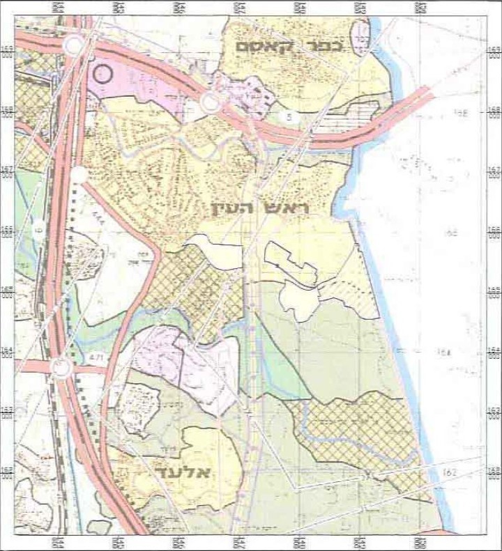
You can see that the whole area east of Rosh HaAyin is painted white, meaning that nothing is planned in it even though it is empty.
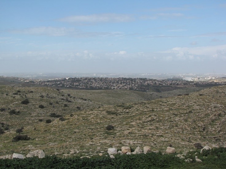
This picture shows a view of Rosh Ha'ayin from the east, which illustrates the folly of being unable to cross the Green Line in construction plans. The erasure of the Green Line by applying sovereignty in Judea and Samaria[40] will release the land reserves of the Dan region and will balance the housing prices there.
[39] Rechalim, Shvut Rachel, Bruchin, and others. Zehut views this method as despicable, because it places the state in the position of a neutral arbitrator between Jews and Arabs, and only when the Arabs attack Jews in a particularly painful manner does the state consider itself obligated to compensate the Jews and therefore approves construction.
[40] As detailed in the political plan.
| << Prev || עברית || Français || Русский || Next >> |